- O Gminie
- Dlaczego warto tu zainwestować
- Wsparcie dla inwestora
- Oferty lokalizacyjne
- Kontakt
 About Commune
 Why invest here
 Investor support
 Location offers
 Contact
- Spotkanie biznesu i samorządu
- Uzdrowisko Miłomłyn
- Lot nad Miłomłynem
- OIOF Miłomłyn
- Sosna Taborska
- Miłomłyn pamięta o Wyklętych
- 20-lecie odzyskania praw miejskich
- Gazyfikacja Miłomłyna
- Miłomłyn z lotu ptaka
- Pozarządowy Miłomłyn
- Miłomłyn dla turystów
- Dożynki Gminne 2018
- Wywiad z Burmistrzem
- 100 rocznica odzyskania Niepodległości
- Miłomłyn inwestuje
- Inwestycje w oświatę
- Jarmark Bożonarodzeniowy 2018
- Gminne spotkania opłatkowe
- Spotkanie noworoczne Burmistrza
- XIII Festiwal Młodych Talentów okiem kamery
- Strażacki Miłomłyn 2019
- Jarmark Regionalny 2019 r.
- Nowe inwestycje w Miłomłynie
- Przeżyjmy to jeszcze raz - Dni Miłomłyna 2019
- Dożynki Gminne 2019 okiem kamery
- Portal E-Usług
- Wieści z gminy
- 2021
- 2020
- 2019
- 2018
- 2017
- 2016
- Kalendarz imprez
- Sprawy Urzędowe
- Strategie i Plany
- Projekty i fundusze
- Projekty UE
- E-Miłomłyn - rozwój nowoczesnych e-usług publicznych
- Leśny Park Uzdrowiskowy w Miłomłynie
- Adaptacja pomieszczeń Szkoły Podstawowej w Miłomłynie na potrzeby utworzenia punktu przedszkolnego wraz z wyposażeniem
- Wymiana systemu grzewczego w Publicznym Gimnazjum im. Ziemi Mazurskiej w Miłomłynie
- Urządzenie odcinka plaży oraz trasy leczenia spacerowego nad jeziorem Ilińsk w Miłomłynie
- Modernizacja Stacji Uzdatniania Wody w Miłomłynie- etapy I i II
- Budowa tężni solankowej
- Cyfrowa Gmina
- Miłomłyn eksperymentuje
- Punkty przedszkolne bez barier
- Kubusiowo – nowe miejsca wychowania przedszkolnego w Miłomłynie
- Gmina Miłomłyn przeciwko wykluczeniu cyfrowemu uczniów - edycja II
- Cyfrowa Gmina – Granty PPGR
- Gmina Miłomłyn przeciwko wykluczeniu cyfrowemu uczniów
- Rozbudowa oczyszczalni ścieków w Miłomłynie - etapy I i II
- Nowoczesne wyposażenie w SP Miłomłyn
- Bezpieczny pieszy w gminie Miłomłyn
- Projekty infrastrukturalne
- Przebudowa drogi gminnej nr 149002N Majdany Wielkie – Bynowo
- Przebudowa ulicy Potockiego w Miłomłynie - etapy I i II
- Przebudowa drogi dojazdowej do Ośrodka zdrowia - ul. Cicha w Miłomłynie
- Przebudowa drogi do miejscowości Ligi - I etap
- Remonty siedzib jednostek OSP w Gminie Miłomłyn
- Odnowienie oraz wykonanie oznakowania nowych szlaków turystycznych Gminy Miłomłyn
- Budowa wieży widokowej w Miłomłynie
- Przebudowa drogi gminnej nr 149005N w miejscowości Ligi - etap II
- Przebudowa nawierzchni jezdni drogi gminnej w miejscowości Gil Mały - etap I
- Przebudowa drogi gminnej nr 149505N i przebudowa drogi wewnętrznej - ul. Jeziorna w Miłomłynie etapy I i II
- Budowa wiaty rowerowej na czerwonym szlaku rowerowym w miejscowości Winiec
- Modernizacja pomieszczeń budynku socjalno-gospodarczego na stadionie miejskim w Miłomłynie – etap I
- Przebudowa ul Sportowej i ul. Zielonej w Miłomłynie
- Przebudowa drogi Miłomłyn - Wielimowo - etap I
- Przebudowa drogi Liwa - Rogowo - etap I
- Modernizacja infrastruktury stadionu miejskiego w Miłomłynie.
- Rozbudowa gminnej sieci wodociągowej Miłomłyn – Malinnik
- Przebudowa drogi gminnej Gil Mały – Gil Wielki
- Modernizacja infrastruktury stadionu miejskiego w Miłomłynie – II etap
- Przebudowa świetlicy wiejskiej w Majdanach Wielkich
- Modernizacja pomostu na Kanale Elbląskim w Miłomłynie
- Rozbudowa wiaty rekreacyjnej w Dębince
- Budowa wiaty służącej aktywności mieszkańców sołectwa Bynowo
- Instalacja fotowoltaiczna dla ośrodka kultury i remizy strażackiej w Miłomłynie
- Modernizacja i remont kompleksu boisk Orlik w Miłomłynie
- Dotacje WFOŚiGW
- Usuwanie wyrobów zawierających azbest z terenu Gminy Miłomłyn
- Rozbudowa oczyszczalni ścieków w miejscowości Miłomłyn - etap I
- Zakup motopompy pożarniczej dla OSP Miłomłyn
- Projekt - Zakup specjalistycznego pakietu osobistego dla członków OSP Bynowo
- Projekt - Zakup butów specjalnych strażackich dla członków OSP Miłomłyn
- Projekt - Zakup specjalistycznego wyposażenia dla członków OSP Liwa
- Kampania edukacyjno-informacyjna Hałas szkodzi zdrowiu
- Ochrona owadów zapylających w Gminie Miłomłyn
- Ochrona owadów zapylających w gminie Miłomłyn – etap II
- Fundusz Sołecki
- Projekty społeczne
- Lokalny Animator Sportu
- Wirtualny spacer po mieście i gminie Miłomłyn
- Umiem pływać 2017
- Fundusz Sprawiedliwości 2018
- Umiem pływać 2018
- Lokalny Animator Sportu 2019
- Umiem Pływać 2019
- Aktywna tablica
- Lokalny Animator Sportu 2020
- Program Posiłek w szkole i w domu
- Miłomłyńskie Święto Plonów 2022
- V Rekonstrukcja historyczna Rozpoczęcia Budowy Kanału Elbląskiego
- Sterylizacja i kastracja psów i kotów w gminie Miłomłyn
- Sadzenie drzew i krzewów miododajnych
- Ekonomia Społeczna
- Wsparcie KOWR
- Dofinansowane z budżetu państwa
- Przebudowa drogi do Rogowa
- Przebudowa drogi do Wielimowa
- Prowadzenie ŚDS
- Modernizacja stadionu w Miłomłynie
- Zakup nowości wydawniczych do placówek wychowania przedszkolnego
- Rozbudowa i modernizacja sieci wodno-kanalizacyjnej w gminie Miłomłyn
- Zakup zestawu narzędzi hydraulicznych dla OSP Miłomłyn
- Przebudowa ul. Kolejowej w Miłomłynie - etap I
- Przebudowa dróg gminnych w m. Karnity i do m. Skarpa
- Rozbudowa gminnej sieci wod-kan przy ul. Zatokowej i terenów uzdrowiskowych strefy A w m. Miłomłyn
- Rozbudowa sieci wod-kan w gminie Miłomłyn - II etap
- Fair-play na macie przeciwko przestępczości
- Mechanizm umożliwiający sygnalizowanie o potencjalnych nieprawidłowościach/ nadużyciach finansowych
- Projekty UE
- Turystyka
- Baza turystyczna
- Szlaki turystyczne
- Przydatne telefony i strony internetowe
- Punkt Informacji Turystycznej w Miłomłynie
- Atrakcje turystyczne gminy
- Kanał Elbląski oraz Obszar Chronionego Krajobrazu Kanału Elbląskiego
- Trasa leczenia spacerowego w Miłomłynie
- Neogotycki Kościół pw. św. Bartłomieja w Miłomłynie
- Wieża dzwonnicza z krużgankami przy kościele w Miłomłynie
- Cmentarz komunalny z XIX w
- Pomnik Danuty Siedzikówny „Inki” w Miłomłynie
- Wieża widokowa w Miłomłynie
- Przystań wodna w Miłomłynie
- Ścieżka dydaktyczna w Rezerwacie Sosny Taborskiej
- Zespół pałacowo-parkowy z XIX w. w Karnitach oraz Bajkowy Świat Kłobuka
- Historyczny układ urbanistyczny Liwy
- Wielimowo
- Winiec
- Tarda
- Piławki
- Liksajny
- Leśny Park Uzdrowiskowy w Miłomłynie
- Plaża miejska w Miłomłynie
- Tężnia solankowa w Miłomłynie
- Spacer po Mieście i Gminie Miłomłyn
- Wpis do ewidencji innych obiektów świadczących usługi hotelarskie
- Oświata
- Kultura i zabytki
- Gminna Komisja Rozwiązywania Problemów Alkoholowych
- Sport
- Zdrowie
- Organizacje pozarządowe
- Podatki i opłaty lokalne
- Środowisko
- Gospodarka Komunalna
- Usuwanie drzew i krzewów
- Ochrona środowiska
- Lasy
- Rolnictwo
- Łowiectwo
- Zabytki na terenie Gminy Miłomłyn
- M-GOPS
- Przedsiębiorstwo Gospodarki Komunalnej
- Ochotnicza Straż Pożarna
- Mapa turystyczna miasta i gminy Miłomłyn
- Jakość powietrza w Miłomłynie
- Tablica informacyjna pyłomierza
- Raporty z jakości powietrza
- Zwierzęta w Gminie
- Projekty UE
- Wolna Ukraina
- Nowy standard DVB-T2
- Szczepienia przeciw Covid 19
- WFOŚiGW
- BIP
- RODO
- Deklaracja dostępności
- Raport o stanie dostępności
- Dokumenty strategiczne
- Imienny rejestr głosowań Rady Miejskiej
- Retransmisje obrad Rady Miejskiej
- Zapytania i interpelacje radnych
- Dyżury Radnych
- Zamówienia publiczne i przetargi
- Ogłoszenia, obwieszczenia, konsultacje społeczne
- Petycje
- Nieruchomości - przetargi, wykazy, ogłoszenia
- Nieruchomości- przetargi, wykazy, ogłoszenia - Krajowy Ośrodek Wsparcia Rolnictwa.
- Nieruchomości- oferty prywatne
- Zarządzanie kryzysowe
- Bezpłatna Pomoc Prawna
- Mapa dojazdu
- Miasto partnerskie
- System Informacji Przestrzennej
- Portal biznes.gov.pl
- Invest in Miłomłyn
- O Gminie
- Dlaczego warto tu zainwestować
- Wsparcie dla inwestora
- Oferty lokalizacyjne
- Kontakt
- About Commune
- Why invest here
- Investor support
- Location offers
- Contact
- Aktualności
- Miasto i Gmina
- Kontakt
- Galeria zdjęć
- Galeria filmów
- Spotkanie biznesu i samorządu
- Uzdrowisko Miłomłyn
- Lot nad Miłomłynem
- OIOF Miłomłyn
- Sosna Taborska
- Miłomłyn pamięta o Wyklętych
- 20-lecie odzyskania praw miejskich
- Gazyfikacja Miłomłyna
- Miłomłyn z lotu ptaka
- Pozarządowy Miłomłyn
- Miłomłyn dla turystów
- Dożynki Gminne 2018
- Wywiad z Burmistrzem
- 100 rocznica odzyskania Niepodległości
- Miłomłyn inwestuje
- Inwestycje w oświatę
- Jarmark Bożonarodzeniowy 2018
- Gminne spotkania opłatkowe
- Spotkanie noworoczne Burmistrza
- XIII Festiwal Młodych Talentów okiem kamery
- Strażacki Miłomłyn 2019
- Jarmark Regionalny 2019 r.
- Nowe inwestycje w Miłomłynie
- Przeżyjmy to jeszcze raz - Dni Miłomłyna 2019
- Dożynki Gminne 2019 okiem kamery
-

- Wieści z gminy
- Kalendarz imprez
- Sprawy Urzędowe
- Strategie i Plany
-
Projekty i fundusze
-
Projekty UE
- E-Miłomłyn - rozwój nowoczesnych e-usług publicznych
- Leśny Park Uzdrowiskowy w Miłomłynie
- Adaptacja pomieszczeń Szkoły Podstawowej w Miłomłynie na potrzeby utworzenia punktu przedszkolnego wraz z wyposażeniem
- Wymiana systemu grzewczego w Publicznym Gimnazjum im. Ziemi Mazurskiej w Miłomłynie
- Urządzenie odcinka plaży oraz trasy leczenia spacerowego nad jeziorem Ilińsk w Miłomłynie
- Modernizacja Stacji Uzdatniania Wody w Miłomłynie- etapy I i II
- Budowa tężni solankowej
- Cyfrowa Gmina
- Miłomłyn eksperymentuje
- Punkty przedszkolne bez barier
- Kubusiowo – nowe miejsca wychowania przedszkolnego w Miłomłynie
- Gmina Miłomłyn przeciwko wykluczeniu cyfrowemu uczniów - edycja II
- Cyfrowa Gmina – Granty PPGR
- Gmina Miłomłyn przeciwko wykluczeniu cyfrowemu uczniów
- Rozbudowa oczyszczalni ścieków w Miłomłynie - etapy I i II
- Nowoczesne wyposażenie w SP Miłomłyn
- Bezpieczny pieszy w gminie Miłomłyn
-
Projekty infrastrukturalne
- Przebudowa drogi gminnej nr 149002N Majdany Wielkie – Bynowo
- Przebudowa ulicy Potockiego w Miłomłynie - etapy I i II
- Przebudowa drogi dojazdowej do Ośrodka zdrowia - ul. Cicha w Miłomłynie
- Przebudowa drogi do miejscowości Ligi - I etap
- Remonty siedzib jednostek OSP w Gminie Miłomłyn
- Odnowienie oraz wykonanie oznakowania nowych szlaków turystycznych Gminy Miłomłyn
- Budowa wieży widokowej w Miłomłynie
- Przebudowa drogi gminnej nr 149005N w miejscowości Ligi - etap II
- Przebudowa nawierzchni jezdni drogi gminnej w miejscowości Gil Mały - etap I
- Przebudowa drogi gminnej nr 149505N i przebudowa drogi wewnętrznej - ul. Jeziorna w Miłomłynie etapy I i II
- Budowa wiaty rowerowej na czerwonym szlaku rowerowym w miejscowości Winiec
- Modernizacja pomieszczeń budynku socjalno-gospodarczego na stadionie miejskim w Miłomłynie – etap I
- Przebudowa ul Sportowej i ul. Zielonej w Miłomłynie
- Przebudowa drogi Miłomłyn - Wielimowo - etap I
- Przebudowa drogi Liwa - Rogowo - etap I
- Modernizacja infrastruktury stadionu miejskiego w Miłomłynie.
- Rozbudowa gminnej sieci wodociągowej Miłomłyn – Malinnik
- Przebudowa drogi gminnej Gil Mały – Gil Wielki
- Modernizacja infrastruktury stadionu miejskiego w Miłomłynie – II etap
- Przebudowa świetlicy wiejskiej w Majdanach Wielkich
- Modernizacja pomostu na Kanale Elbląskim w Miłomłynie
- Rozbudowa wiaty rekreacyjnej w Dębince
- Budowa wiaty służącej aktywności mieszkańców sołectwa Bynowo
- Instalacja fotowoltaiczna dla ośrodka kultury i remizy strażackiej w Miłomłynie
- Modernizacja i remont kompleksu boisk Orlik w Miłomłynie
-
Dotacje WFOŚiGW
- Usuwanie wyrobów zawierających azbest z terenu Gminy Miłomłyn
- Rozbudowa oczyszczalni ścieków w miejscowości Miłomłyn - etap I
- Zakup motopompy pożarniczej dla OSP Miłomłyn
- Projekt - Zakup specjalistycznego pakietu osobistego dla członków OSP Bynowo
- Projekt - Zakup butów specjalnych strażackich dla członków OSP Miłomłyn
- Projekt - Zakup specjalistycznego wyposażenia dla członków OSP Liwa
- Kampania edukacyjno-informacyjna Hałas szkodzi zdrowiu
- Ochrona owadów zapylających w Gminie Miłomłyn
- Ochrona owadów zapylających w gminie Miłomłyn – etap II
- Fundusz Sołecki
-
Projekty społeczne
- Lokalny Animator Sportu
- Wirtualny spacer po mieście i gminie Miłomłyn
- Umiem pływać 2017
- Fundusz Sprawiedliwości 2018
- Umiem pływać 2018
- Lokalny Animator Sportu 2019
- Umiem Pływać 2019
- Aktywna tablica
- Lokalny Animator Sportu 2020
- Program Posiłek w szkole i w domu
- Miłomłyńskie Święto Plonów 2022
- V Rekonstrukcja historyczna Rozpoczęcia Budowy Kanału Elbląskiego
- Sterylizacja i kastracja psów i kotów w gminie Miłomłyn
- Sadzenie drzew i krzewów miododajnych
- Ekonomia Społeczna
- Wsparcie KOWR
-
Dofinansowane z budżetu państwa
- Przebudowa drogi do Rogowa
- Przebudowa drogi do Wielimowa
- Prowadzenie ŚDS
- Modernizacja stadionu w Miłomłynie
- Zakup nowości wydawniczych do placówek wychowania przedszkolnego
- Rozbudowa i modernizacja sieci wodno-kanalizacyjnej w gminie Miłomłyn
- Zakup zestawu narzędzi hydraulicznych dla OSP Miłomłyn
- Przebudowa ul. Kolejowej w Miłomłynie - etap I
- Przebudowa dróg gminnych w m. Karnity i do m. Skarpa
- Rozbudowa gminnej sieci wod-kan przy ul. Zatokowej i terenów uzdrowiskowych strefy A w m. Miłomłyn
- Rozbudowa sieci wod-kan w gminie Miłomłyn - II etap
- Fair-play na macie przeciwko przestępczości
- Mechanizm umożliwiający sygnalizowanie o potencjalnych nieprawidłowościach/ nadużyciach finansowych
-
Projekty UE
-
Turystyka
- Baza turystyczna
- Szlaki turystyczne
- Przydatne telefony i strony internetowe
- Punkt Informacji Turystycznej w Miłomłynie
-
Atrakcje turystyczne gminy
- Kanał Elbląski oraz Obszar Chronionego Krajobrazu Kanału Elbląskiego
- Trasa leczenia spacerowego w Miłomłynie
- Neogotycki Kościół pw. św. Bartłomieja w Miłomłynie
- Wieża dzwonnicza z krużgankami przy kościele w Miłomłynie
- Cmentarz komunalny z XIX w
- Pomnik Danuty Siedzikówny „Inki” w Miłomłynie
- Wieża widokowa w Miłomłynie
- Przystań wodna w Miłomłynie
- Ścieżka dydaktyczna w Rezerwacie Sosny Taborskiej
- Zespół pałacowo-parkowy z XIX w. w Karnitach oraz Bajkowy Świat Kłobuka
- Historyczny układ urbanistyczny Liwy
- Wielimowo
- Winiec
- Tarda
- Piławki
- Liksajny
- Leśny Park Uzdrowiskowy w Miłomłynie
- Plaża miejska w Miłomłynie
- Tężnia solankowa w Miłomłynie
- Spacer po Mieście i Gminie Miłomłyn
- Wpis do ewidencji innych obiektów świadczących usługi hotelarskie
- Oświata
- Kultura i zabytki
- Gminna Komisja Rozwiązywania Problemów Alkoholowych
- Sport
- Zdrowie
- Organizacje pozarządowe
- Podatki i opłaty lokalne
- Środowisko
- Zabytki na terenie Gminy Miłomłyn
- M-GOPS
- Przedsiębiorstwo Gospodarki Komunalnej
- Ochotnicza Straż Pożarna
-

-

- Tablica informacyjna pyłomierza
- Raporty z jakości powietrza
Location offers
Area covered by the current spatial development plan for industry and service purposes, comprising land plot 138/74 with an area of 2,2092 ha. It is located in Miłomłyn, between Polna and Potocki streets, and is equipped with power, water and sewage networks.

Date of last update: 1 march 2018 year
Area covered by the current spatial development plan is intended for single family housing and service development, service development or production and service development purposes. The area covers 22 plots (4 hectares) and is located in Miłomłyn between Kolejowa and Polna streets. It is equipped with a power and water network as well as hardened road.

Date of last update: 1 march 2018 year
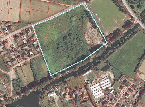
The area covered by the current spatial development plan is intended for a yacht port with accompanying infrastructure. It includes lots No. 81/2 and No. 81/3 (3,1779 ha) located in Miłomłyn directly at the Elbląg Canal, near the Miłomłyn Sluice. It is equipped with a power and water network as well as hardened road.

Date of last update: 1 march 2018 year
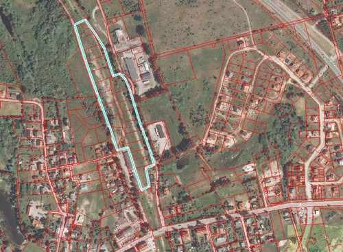
Land property located in the center of Miłomłyn, directly at Twarda street (the main access road leading to the town of Miłomłyn). The plot is a part of the former railroad track. The land is undeveloped, located between multifamily and single family housing. Shape of the parcel is irregular and elongated. A water pipe runs through the plot, which may be connected to sewage and power networks. The land property is covered by the current spatial development plan and is in part intended for housing and service development and in part for service development purposes.

Date of last update: 1 march 2018 year
- Zwierzęta w Gminie


- BIP
- RODO
- Deklaracja dostępności
- Raport o stanie dostępności
- Dokumenty strategiczne
- Imienny rejestr głosowań Rady Miejskiej
- Retransmisje obrad Rady Miejskiej
- Zapytania i interpelacje radnych
- Dyżury Radnych
- Zamówienia publiczne i przetargi
- Ogłoszenia, obwieszczenia, konsultacje społeczne
- Petycje
- Nieruchomości - przetargi, wykazy, ogłoszenia
- Nieruchomości- przetargi, wykazy, ogłoszenia - Krajowy Ośrodek Wsparcia Rolnictwa.
- Nieruchomości- oferty prywatne
- Zarządzanie kryzysowe
- Bezpłatna Pomoc Prawna


Urząd Miasta i Gminy Miłomłyn
ul. Twarda 12, 14-140 Miłomłyn
Tel.: 89 6425801
E-mail: gmina@milomlyn.pl


